GENERAL INFORMATION
 |
The Dzukija National Park was
established on 23 April, 1991 according to the Supreme
Council decree No. I-244 of the Republic of Lithuania to
protect, manage and utilise the richest, naturally and
culturally, territories of Dainava land. The principal
object is to protect parficularly valuable natural and
cultural complexes of Dainava land, to cherish cultural
traditions of Dzukija, to spread traditional farming
methods and to form conditions for cognitive tourism. It
is the largest territory protected in Lithuania of 55,900
hectares. Forests cover 43700 hectares. The major part of
the park lies in Varena district (ca 95%) while smaller
parts cover Alytus district (ca 4%) and Lazdijai district
(ca 1 %). The park is situated in Lithuania's south, at
100 km south-west from Vilnius and 100 km south from Kaunas. |
| The park is maintained by 200
workers. Its territory is divided into 10 forestry
districts. Merkine small town and 79 villages are
inhabited by a population of 4,000. Over 50% of park
inhabitants are of retirement age and only 10% are
younger than 15. The largest settlements of the Dzukija
National Park are Merkine (1590 inhabitants), Marcinkonys
(866), Panara (263) Musteika (104) and Margionys (91 ).
The park belongs to the Federation of European National
Parks and the Association of Baltic National Parks. |
| Relief. The
Dzukija National Park lies in the south of the Dainava
sandy plain. North-westem edge of the park climbs on the
Dzukai hill. The dividing line belween these areas goes
by Veisiejai-Merkine morainal hilly track. Around two
thirds of the park territory lie in a sandy plain
channeled bysteep slopes with river valleys of distinct
terraces. The most unique park landscapes are the
mainland dune massifs of Marcinkonys, Lynežeris,
Grubaulia and Šunupis. These were formed after the
second stage of the glacial period (30,000 years ago).
The surface of the plain is varied by ravines with small
lakes. At Merkine, the morainal highness is dominated by
landscapes of average hilly ravines, different soil and
farming land covers and chains of lakes. Where the waters
of the Nemunas river had broken a morainal |
 |
| crest, now stony shoals are set
(Noblewoman by Ulčičiai, Falcon by Dubaklonis, Scissors
by Merkine, Sewer by Maksimonys). Before gnawing though
the morainal crest, the river wandered into different
directions for a while leaving a valley of 4-6 km (near
Panara and Netiesa villages, in particular) and the
curves of old river-beds of 2-3 km radius (Pakrykšte
marsh). The park's territory is at 100 m above sea-level
on the average. The highest point is Dalgiakalnis hill
(168.2 m above sea-level) that is found in the massif of
lowland dunes at 4 km distance north-east from
Marcinkonys. The lowest place is a channel ofthe Nemunas
riverat Krikštonys (66 m above sea- level). |
 |
Climate. The
park's climate is more continental than in other parts of
Lithuania. The sun radiation received is one of the
highest in Lithuania. Sharp fluctuations of day and
annual temperature as well as the earliest and the
latest frosts are noticeable. The average temperature in
January falls to-5.4 C, maximum down to - 40.0 °C. In
July, the average temperature is +17.7°C and may rise
at most to +37.0 °C (the highest in Lithuania).
Soils.
Within the territory of the park, parficularly in the
south-east plain, inferfile podzolic sandy soils
dominate. To the north-eas of Merkine and in the environs
of Žeimiai, turfen podzolic sandy and sandy loam soils
are found; in higher zones, these soils are interfered
with turfen carbonate sandy soils ripped off on gravel.
Typical turfen carbonate soils, formed on freshwater
limestone lens or lime layers, are spread in the valleys
of the Skroblus and other rivers and lake shores.
Alluvial soils may also be discovered in river valleys.
Marshy soils of lower type expand in the upper and the
middle Skroblus, the upper Gruda and the valleys of
Šilinge, Pakrykšte and Kempe. Higher marshy soils are
mostly found in the southem park territory, the environs
of Musteika village. |
VALUES
 |
The Dzukija National Park is
divided into 4 functional zones: preservative,
protective, recreational and economic. The preservative
zone (reservations and preserves) occupies 262 580
thousand hedares (47.5% of territory). The stridest
protection regime is applied to 3 reservations that cover
2 080 hectares in total. The Musteika reservation
stretches through the upper reaches of Musteika brook and
the surrounding forests. The Povilnis reservation
preservesthe outset sources of Povilnis rivulet, suffosic
circuses and canyon-like upper reaches of the rivulet
valley. The Skroblus reservation includes the middle
reaches of Skroblus rivulet and its lower reaches |
| between Kapiniškiai and
Dubininkas villages. The landscape preservations occupy
13 060 hectares. The richest sections of the Nemunas, the
Merkys and the Ula rivers were announced to be the
preserves of the park. The unique source and higher
reaches of Skroblus rivulet with abundant springs, its
wide valley with a structurally charaderistic land-tenure
of Kapiniškiai village and the ethnographi-
callyvaluable Margionys village are secured bythe
Kapiniškiai preserve. In the norfhwestern parf of the
park, the Lizdai preserve protects a distinct morainal
hill-chain with deep thermocarstic pits, Lizdai, Galvinis
and Bedugnis lakes, lake shore marshes and the Ežerynas
camp of the Stone Age. Many archeological riches arefound
in the Glynas landscape preserve which includes Lake
Glynas, Glynupis brook and a complex of five old camping
places. Other natural preserves occupy 10 600 hectares
dominated by geomorphologic preserves protecting
characteristic to Dzukija and other unique elements of
landscape. For the preservation of Dzukija continental
dunes, even 4 preserves - Alkunes kampas, Dreves,
Marcinkonys and Šunupis - were established. Ucieka,
Gudeliai and Pakrukšte geomorphologic preserves were
formed to maintain the characteristic relief elements of
the Nemunas valley. |
| The relief of the southern
slopes of Dzukija morainal highlands is well represented
by the Merkine geomorphologic preserve located norfhwards
of Merkine small town. The most cherished elements of the
river-chain of Dzukija are also preserved in hydrographic
preserves, the Gnuda and the Netiesos. Scarce marshes of
the Dzukija National Park are protected in thermologic
preserves - Delynas, Didžiabale, Bakanauskai and
Imškos. The single botanical preserve of Subartonys
forest protects rarely met spruce groves mixed with oak-
trees and rich grasses that are characteristic to Dzukai
high- lands. The park keeps 60 natural monuments,
including 18 landscape objects - precipices of the Ula,
the Merkys and the Nemunas, fascinating ravines, springs,
rock exposures, mountain-ridges, chasms and lakes. The
most outstanding natural monuments are considered to be
the spring "Ula eye", old bee-keeping relics -
the hollow pines, the lime tree Lietuvis (Lithuanian) in
Margionys village and Zenynai oak. |
 |
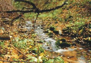
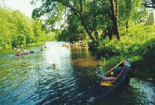
Rivers.
The park's territory belongs to the Nemunas river basin. The park
includes the Middle Nemunas, the sections of the Merkys, the Ula
and the Gruda rivers and the unique Skroblus rivulet - 30 large
and small rivers in total which are nourished by ground water.
Therefore, the flow of rivers and Merkys river - 700 litres per
second. There is no other so shorf and deep brook in Lithuania.
Geomorphologic processes take place in the Skroblus river basin
very intensively. Some pits particularly capture one' s attention
- they are deep, steep and shady.
Lakes.
The Dzukija National Park has 48 lakes the total space of which
is 232 hectares. The largest lakes are Lizdai (27 ha), Lynas
(18.5 ha), Gelovine (15.9 ha), Glynas (15.2 ha), Galvinis (12.4
ha), Gilse (10.6 ha) and Kastinis (10.1 ha). In the norfh-west
part of the park, where the ravine vale crossesthe sandy terraced
plain of the Nemunas river, Krokinis, Ežerinis, Lizdai,
Galvinis, Kazamkelis, Bedugnis, Giluišis Balaežeris, Netiesis,
Netieselis, Dumblinis, Pakampis, Ešerinis Pilselis and Lauja
lakes are centered. Gelovine, Gilše, Kampinis, Pakelinis and
Linmarkas lakes lie in the Masališkis pit, near Subartonys.
These lakes are mostly narrow, deep, with steep shores and
meandering. In the territory of the old valley (lower terrace)
lakes Mergeles akeles and Glynas are found.
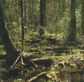
| Most of the territory is
covered by forests where pineries dominate (92%). The
commonest pine forests are of lichen (51 %) and cowberry
(33%) sorf. Their warmth-loving plants predetermine the
floral uniqueness of the Dainava plain. Sprucegroves are
mostly characteristic to highlands, to the norfh of
Merkine. Black alder groves concentrate near marshes and
in rivervalleys. Birch groves usually gather in former
places of conifers and mixed forests. Elmgroves near the
valleys of springy rivers, the Nemunas in parficular, are
notable fortheir originality. In the Dzukai hill and in
dry river slopes, small thermophylic shrubbery may be
found where hawthorns, spindle-trees, buckthoms and other
shrubs grow. Ripe tree groups form only 2%. The average
age of tree group is 55 years. |
 |
| Marshes. The
largest marsh areas are in the park's south , around
Musteika village. The marsh flora is also spread in the
shores of singular lakes. Small marshes are found in
lowered hilly areas of the park at Subarfonys. Very
peculiarfloral populations of intermediate marshes are
concentrated in the valley of Kempe rivulet and the
marshy Skroblus valley in Kapiniškes - so called
Skerdzimai meadow. In bigger marshes, the flora of
various marsh lypes - lower, intermediate or higher - may
be found. In smaller ones, the floral population is less
diverse, since the flora of low marshes dominates.
Natural or seminatural meadows account for a small
number. They are concentrated in the valley and hill
slopes. Many varieties came to Lithuania by river valleys
and sandy plains from south-eastem and central Europe.
For this reason, many limit-spreading variables, which
are absent or very rare in other parts of Lithuania, now
may be found in the Dzukija National Park. Most of these
species are included into the list of protected plants.
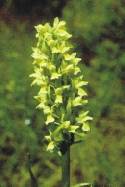
Besides, in the park, certain species where found that
are very infrequent in Lithuania and attributed only to
10 finding places - Equisetum telmateia, Dentaria
bulbifera, red helleborine (Cephalantera rubra), western
marsh orchid (Dactylorhiza majalis), Botrychium
matricariifolium and B. virginianum and other. |
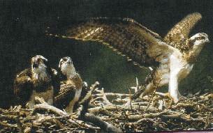 |
The forests of the park give
the richest mushroom crop known forotters (Lutra lutra),
beavers (Castorfiber) and minks in Lithuania. Among
edible mushrooms - boletus and chan- (Lutreola vison).
Such rare animals as mountain hare (Lepus terelle are
widespread. In the gravelled hills of Merkine timidus)
and common dormouse (Glis glis) are also found in and
Liškiava, saffron milk-caps are not rare, while in the
the National Park. Sands of Marcinkonys environs, green
muschrooms pour out in autumn. There are around 300
mushroom species stated in the park territory, including
10 protected sorts, though this is not the limit as the
exploration of the |
| park's mushrooms is rather poor
Even 212 lichen species were discovered in the park
within 400 sorfs known in Lithuania. Lichen appears on
various trees, rotten stumps, soil and granite pebbles.
In clean brooklets, even water lichen was found. The
lichen flora of pine forests is very rich and diverse. |
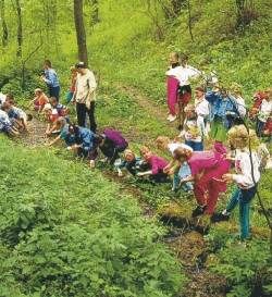
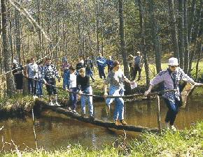
VISITORS
| The Dzukija National
Park provides acquaintance with natural riches of
Dzukija, the households, traditions and customs of dzukai
living in different areas. The most popular and
comfortableform ofvisiting the park is autotourism. The
present road network is convenient to access Marcinkonys
and Merkine. The number of asphalt roads increases each
year, though many visitable places can be reached only by
gravel highways or forest roads. For organised park
visitors, excursions by bus are proposed. Neverfheless,
the very beauly of Dzukija land may be grasped bywalking
on foot or driving on bicycles. For the comforf of park
visitors, many relaxation grounds, arbours, bonfire
places, foot-bridges and paths to springs are arranged.
The park has four pedestrian passages. In Marcinkonys,
starfing from the ethnocultural and educational centre of
environmental preservation, the route begins by Girinis
(3.6 km) and Zackagiris (4.8 km and 13 km circular
routes) paths in picturesque environs of Marcinkonys. Not
far away from Marcinkonys, by the northwestedge ofthe
Čepkeliai reservation, a path 1.5 km acquaints |
 |
| with the
unique nature of Dzukija dunes and Čepkeliai bog. Out of
the watch-tower, wide spaces of the bog lie open to the
eye. Forthose who want to see the marsh from near, a
foot-bridge is laid across. This path may be visited only
with an accompanying staff of the National Park or the
Čepkeliai reservation. From 1 April to 1 June only small
groups of visitors are accepted. One more road (2 km)
starfs from Merkine mould and twists along the meadows
and forests of the confluence of the Merkys and the
Nemunas rivers. |
 |
We recommend to starf
the acquaintance with the park from the information
centres of Marcinkonys and Merkine. Here, you will find
excursion guides and available information on the park's
visiting, camping places and accommodation in villages
orto watch videotapes about the park. Information centres
constantly hold art exhibitions and sell souvenirs and
booklets. For more exhaustive information about the
nature and culture of Dzukija, we would recommend to
visit the educational centre of environmental
preservation and ethnography in Marcinkonys where
qualified specialists of the National Park provide services. |
| The centre
has convenient facilities to organize seminars,
conferences, schools of traditional trades (for groups of
not more than 25 parficipants); all necessary equipment
is available. Five museums opened in the territory of the
park will help you to know the rich history and culture
of Dainava land: - Alytus museum of local ethnography,
Merkine branch (Merkine, central square); - Historical
museum of Lithuania's fights and sufferings for freedom
(Seinai str 8, Merkine); - House-museum of Vincas
Kreve-Mickevičius in Subartonys; - Ethnographic museum
of the Dzukija National Park (Miškininku str 6,
Marcinkonys); - A branch of Kaunas zoological museum of
Tadas Ivanauskas in Čepkeliai state reservation
(Šilageliu str 11, Marcinkonys). |
 |
The travelers of the
park may accommodate in Druskininkai and Varena hotels
and recreational apartments of Marcinkonys educational
centre of environmental preservation and ethnography
(Administrator's phone No: (370 60) 44469). For those who
prefer to spend nights in tents, 15 camping places are
arranged. In Merkine, approximately 30 people can pass
the night in private farmsteads. The addresses are
provided by the staff of Merkine information centre. You
can have a meal in several cafes in Liškiava,
Marcinkonys and Merkine. Food stores are in Marcinkonys,
Merkine, Liškiava, Kibysiai, Subartonys, Puvočiai,
Margionys, Musteika and Panara. |
Information:
- Marcinkonys information
centre, Miškininku str. 61, Marcinkonys, 4670 Varena region, fax
(370 60) 44471, phone 44466;
- Educational centre of
environmental preservation and ethnoculture, Miškininku str 61,
Marcinkonys, 4670 Varena region. Phone (370 60) 44467
(environmental education), 44465 (ethnography), fax 44471.
- Merkine information centre,
Vilniaus str. 2, Merkine, 4651 Varena region, phone (370 60)
57245.
.